Monday, August 15, 2016

Anaconda MT./Yellowstone WY.


Anaconda was founded by Marcus Daly, one of the Copper Kings, who financed the construction of a smelter on nearby Warm Springs Creek to process copper ore from the Butte mines. In June 1883, Daly filed for a town plat for “Copperopolis,” but that name was already used by another mining town in Meagher County. Instead, Daly accepted the name "Anaconda," suggested by the United States postmaster of the time, Clinton Moore. When Montana was admitted as a state in 1889, Daly lobbied to have the capital moved here, but it stayed in Helena, a location supported by rival William Andrews Clark.

The National Bison Range (NBR) is a National Wildlife Refuge located in western Montana established in 1908 to provide a sanctuary for the American bison. The NBR is one of the oldest National Wildlife Refuges in the United States. The size of the bison herd at the NBR is relatively small, numbering between 350 and 500 individuals.


Big Horned sheep and Antelope were just a few of the other animals we saw here.


A waterfall near Phillipsburg, MT. where we went Sapphire mining.


Yellowstone National Park is a national park located primarily in the U.S. state of Wyoming, although it also extends into Montana and Idaho. It was established by the U.S. Congress and signed into law by President Ulysses S. Grant on March 1, 1872. Yellowstone, the first National Park in the U.S. and widely held to be the first national park in the world, is known for its wildlife and its many geothermal features, especially Old Faithful Geyser, one of the most popular features in the park.


Yellowstone National Park spans an area of 3,468.4 square miles (8,983 km2),  comprising lakes, canyons, rivers and mountain ranges. Yellowstone Lake is one of the largest high-elevation lakes in North America and is centered over the Yellowstone Caldera, the largest supervolcano on the continent.


In 1806, John Colter, a member of the Lewis and Clark Expedition, left to join a group of fur trappers. After splitting up with the other trappers in 1807, Colter passed through a portion of what later became the park, during the winter of 1807–1808. He observed at least one geothermal area in the northeastern section of the park, near Tower Fall. After surviving wounds he suffered in a battle with members of the Crow and Blackfoot tribes in 1809, Colter described a place of "fire and brimstone" that most people dismissed as delirium; the supposedly imaginary place was nicknamed "Colter's Hell". Over the next 40 years, numerous reports from mountain men and trappers told of boiling mud, steaming rivers, and petrified trees, yet most of these reports were believed at the time to be myth.


A good view of how thin the crust of land laying over the basin's really is, it is as thin as pie crust in many areas, though to look at the ground it would seem normal, it is anything but.
Hot boiling water lye just under the surface.


 A boiling waterfall, hot boiling sulfuric Basin water pours into the River creating a sizzling, steaming combination.


Little known fact, A man named Gerald Ford whom was not only an American politician who served as the 38th President of the United States from 1974 to 1977, as well as being a member of the Boy Scouts of America was also a Park Ranger in the 30's for Yellowstone National Park, he gave tours and lessons about the park, he stayed and worked in the Uncle Tom lookout area, around the upper and lower falls area of the park, it was where the staff housing was at the time and is now a parking lot for the stop.


 The most famous geyser in the park, and perhaps the world, is Old Faithful Geyser, located in Upper Geyser Basin. Castle Geyser, Lion Geyser and Beehive Geyser are in the same basin. The park contains the largest active geyser in the world—Steamboat Geyser in the Norris Geyser Basin. A study that was completed in 2011 found that at least 1283 geysers have erupted in Yellowstone. Of these, an average of 465 are active in a given year. Yellowstone contains at least 10,000 geothermal features altogether. Half the geothermal features and two-thirds of the world's geysers are concentrated in Yellowstone.


 With almost two million visitors a week in the summer months you can imagine just how popular this park really is, that's on the same scale as Disney world, with so many examples of God's creation and beauty it is no wonder why it inspires such awe and draws people of all nations in.

View of the Grand Teton Mountain's , though I only drove through this park the scenery was amazing. It always amazes me how mother nature can bring people together, while here we saw people of all nations and creeds and accents, no one fought, no one was angry, they were all just soaking in the great wonder that is our home. It just goes to prove that the only true peacemaker and keeper is our creator. May our future bring a great peace, until next time be kind to one another.

Thursday, July 14, 2016

Seattle Washington/Vancouver BC

Seattle Washington:
The Seattle area was previously inhabited by Native Americans for at least 4,000 years before the first permanent European settlers. Arthur A. Denny and his group of travelers, subsequently known as the Denny Party, arrived from Illinois via Portland, Oregon, on the schooner Exact at Alki Point on November 13, 1851. The settlement was moved to the eastern shore of Elliott Bay and named "Seattle" in 1852, after Chief Si'ahl of the local Duwamish and Suquamish tribes.
Seattle is also home to more big businesses than you even realize, I was surprised to learn of just how many, as a matter of fact Elliott Bay was the place where one of them got its start, you might recognize it, its called E-Bay, or maybe you've heard of google?, Amazon?, Nordstroms?,  or maybe Starbucks Coffee? That's right and many more.

Seattle has a history of boom-and-bust cycles, like many other cities near areas of extensive natural and mineral resources. Seattle has risen several times economically, then gone into precipitous decline, but it has typically used those periods to rebuild solid infrastructure.
The first such boom, covering the early years of the city, rode on the lumber industry. (During this period the road now known as Yesler Way won the nickname "Skid Road", supposedly after the timber skidding down the hill to Henry Yesler's sawmill. The later dereliction of the area may be a possible origin for the term which later entered the wider American lexicon as Skid Row.)
Like much of the American West, Seattle saw numerous conflicts between labor and management, as well as ethnic tensions that culminated in the anti-Chinese riots of 1885–1886. This violence originated with unemployed whites who were determined to drive the Chinese from Seattle (anti-Chinese riots also occurred in Tacoma). In 1900, Asians were 4.2% of the population. Authorities declared martial law and federal troops arrived to put down the disorder.
Seattle achieved sufficient economic success that when the Great Seattle Fire of 1889 destroyed the central business district, a far grander city-center rapidly emerged in its place.
The Great Seattle Fire was a fire that destroyed the entire central business district of Seattle, Washington, on June 6, 1889. The fire burned for several hours, destroying 25 blocks and causing as much as $20 million in damage ($527 million in today's dollars). As a result of the fire, streets in the Pioneer Square neighborhood in Seattle were elevated 22 feet (6.7 m) above the pre-fire street level and new buildings made of wood were banned.
Which leads us to one of Seattle's least known and very cool secrets, there's a city underground!


Despite the magnitude of destruction, the rebuilding effort began quickly. Rather than starting over somewhere else, Seattle's citizens decided to rebuild.
Seattle rebuilt from the ashes quickly. A new building ordinance resulted in a downtown of brick and stone buildings, rather than wood; and at the same time the street levels were raised by up to 22 feet.
Due to a fast growing population and limited space they chose rebuild the old city, then built all the sidewalks and roads on top of the old and added two more stories to the top of the original buildings, so the first floor in the buildings on Pioneer Square are actually the 2nd floor.

 Skylights were put into the sidewalks they built so the underground stores would still have lighting. They still work today!
You could walk over these throughout the city and never know you were walking over the old underground.


                                                        Vancouver,BC!

The original settlement, named Gastown, grew up on clearcuts on the west edge of the Hastings Mill logging sawmill's property, where a makeshift tavern had been set up on a plank between two stumps and the proprietor, Gassy Jack, persuaded the curious millworkers to build him a tavern, on 1 July 1867. From that first enterprise, other stores and some hotels quickly appeared along the waterfront to the west. Gastown became formally laid out as a registered townsite dubbed Granville, B.I. ("B.I" standing for "Burrard Inlet"). As part of the land and political deal whereby the area of the townsite was made the railhead of the CPR, it was renamed "Vancouver" and incorporated shortly thereafter as a city, in 1886. By 1887, the transcontinental railway was extended to the city to take advantage of its large natural seaport, which soon became a vital link in a trade route between the Orient, Eastern Canada, and Europe.

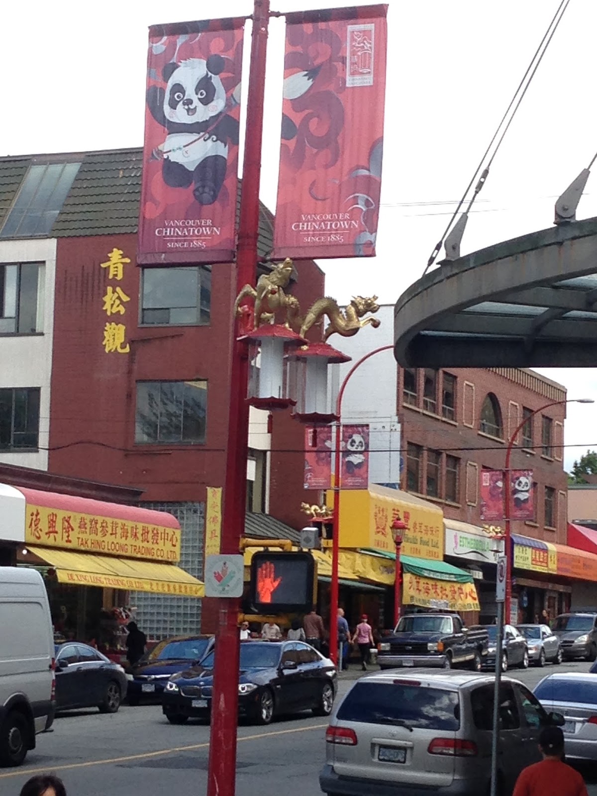
 Chinatown in Vancouver, British Columbia is Canada's largest Chinatown.
Chinatown was once known for its neon signs but like the rest of the city lost many of the spectacular signs to changing times and a new sign by law passed in 1974. The last of these was the Ho Ho sign (which showed a rice bowl and chop sticks) which was removed in 1997. Ongoing efforts at revitalization include efforts by the business community to improve safety by hiring private security; looking at new marketing promotions and introducing residential units into the neighbourhood by restoring and renovating some of the heritage buildings. Current focus is on the restoration and adaptive reuse of the distinctive Association buildings.

Once the epicenter for commerce has now deteriorated to becoming the ghetto. 
These are some of the art pieces that have been created to try to bring Chinatown back from decay. this is a large scale abacus.

Some of the markets in Chinatown that are still surviving.


Views from the Vancouver lookout, it's thier version of a space needle.


The Lions Gate Bridge, opened in 1938, officially known as the First Narrows Bridge, is a suspension bridge that crosses the first narrows of Burrard Inlet and connects the City of Vancouver, British Columbia, to the North Shore municipalities of the District of North Vancouver, the City of North Vancouver, and West Vancouver. The term "Lions Gate" refers to The Lions, a pair of mountain peaks north of Vancouver. Northbound traffic on the bridge heads in their general direction. A pair of cast concrete lions, designed by sculptor Charles Marega, were placed on either side of the south approach to the bridge in January, 1939.

Canada's First Nation's 
Archaeological records indicate the presence of Aboriginal people in the Vancouver area from 8,000 to 10,000 years ago. The city is located in the traditional territories of the Squamish, Musqueam, and Tseil-Waututh (Burrard) peoples of the Coast Salish group. They had villages in various parts of present-day Vancouver, such as Stanley Park, False Creek, Kitsilano, Point Grey and near the mouth of the Fraser River.


These Statues (not totems) tell stories of the people and tribes, they are recreations of the originals done by remaining First Nation's artist's and donated to Stanley Park. 


I absolutely loved our visit to Canada, it was a beautiful place in Vancouver with lot's of history and culture.
Our own country is in great turmoil currently and I feel that all to often we forget our own history and the lessons that it should have taught us, it's important to know where we came from and the mistakes that were made, it's what keeps people from making them again.
I would like to invite everyone to remember and forgive so that our future can be a safe and bright one.
Be kind to one another. Until next time.

Monday, June 20, 2016

Crater Lake/Mount Hood, Oregon.


Crater Lake  is a caldera lake in the western United States, located in south-central Oregon. It is the main feature of Crater Lake National Park and is famous for its deep blue color and water clarity. The lake partly fills a nearly 2,148-foot (655 m)-deep caldera that was formed around 7,700 (± 150) years ago by the collapse of the volcano Mount Mazama. There are no rivers flowing into or out of the lake; the evaporation is compensated for by rain and snowfall at a rate such that the total amount of water is replaced every 250 years. With a depth of 1,949 feet (594 m), the lake is the deepest in the United States. In the world, it ranks tenth for maximum depth, and third for mean (average) depth.
This place was so beautiful, the deepest snow I've ever seen just miles from a 70 degree day, the water was the clearest crystal blue, nature at its purest. 

Mount Hood, called Wy'east by the Multnomah tribe, is a potentially active stratovolcano in the Cascade Volcanic Arc of northern Oregon. In addition to being Oregon's highest mountain, it is one of the loftiest mountains in the nation based on its prominence.
The most northwestern pass around the mountain is called Lolo Pass. Native Americans crossed the pass while traveling between the Willamette Valley and Celilo Falls.
The Multnomah name for Mount Hood was Wy'east. In one version of the legend, the two sons of the Great Spirit Sahale fell in love with the beautiful maiden Loowit, who could not decide which to choose. The two braves, Wy'east and Klickitat, burned forests and villages in their battle over her. Sahale became enraged and smote the three lovers. Seeing what he had done, he erected three mountain peaks to mark where each fell. He made beautiful Mount St. Helens for Loowit, proud and erect Mount Hood for Wy'east, and the somber Mount Adams for the mourning Klickitat.The mountain was given its present name on October 29, 1792, by Lt. William Broughton, a member of Captain George Vancouver's discovery expedition.


Crater Lake National Park is a United States National Park located in southern Oregon. Established in 1902, Crater Lake National Park is the fifth oldest national park in the United States and the only national park in Oregon.


Local Native Americans witnessed the collapse of Mount Mazama and kept the event alive in their legends. One ancient legend of the Klamath people closely parallels the geologic story which emerges from today's scientific research. The legend tells of two Chiefs, Llao of the Below World and Skell of the Above World, pitted in a battle which ended up in the destruction of Llao's home, Mt. Mazama. The battle was witnessed in the eruption of Mt. Mazama and the creation of Crater Lake.
A trio of gold prospectors: John Wesley Hillman, Henry Klippel, and Isaac Skeeters were the first white people to visit the lake. On June 12, 1853, they stumbled upon the long, sloping mountain while hunting for provisions. Stunned by vibrant blue color of the lake, they named the indigo body of water "Deep Blue Lake" and the place on the southwest side of the rim where he first saw the lake later became known as Discovery Point. But gold was more on the minds of settlers at the time and the discovery was soon forgotten. The suggested name later fell out of favor by locals, who preferred the name Crater Lake.


Multnomah Falls is the tallest waterfall in the state of Oregon. It is credited by a sign at the site of the falls, and by the United States Forest Service, as the second tallest year-round waterfall in the United States.

The Multnomah people are a band of the Chinook Tribe who originally resided on and near Sauvie Island in Oregon. The Multnomah and the related Clackamas tribes lived in a series of villages along the river near the mouth of the Willamette River on the Columbia River (the Willamette was also called the "Multnomah" in the early 19th century). According to archaeologists, the villages in the area were home to approximately 3,400 people year-round, and as many as 8,000 during fishing and wappato-harvesting seasons (wappato is a marsh-grown plant like a potato or onion and a staple food).
In 1830, a disease generally thought to have been malaria devastated the Multnomah villages. Within five years, the village of Cathlapotle was abandoned and was briefly inhabited by the Cowlitz tribe. The Multnomah people had nearly been wiped out by the year 1834 due to malaria and smallpox outbreaks. With only a few Multnomah left by the year 1910, the remaining people were transferred to the Grand Ronde Reservation which is also located in the Northwest of Oregon.


 Oregon is a breathtaking state, it's one of my favorite states and I always enjoy coming here. It's full of history, rich in scenery and boasts a kindhearted people. They have trouble backing up safely and merging but their very nice.
until next time.

Monday, May 16, 2016

San Francisco/Napa Valley

San Francisco, it encompasses a land area of about 46.9 square miles (121 km2) on the northern end of the San Francisco Peninsula, which makes it the smallest county in the state. It has a density of about 18,451 people per square mile (7,124 people per km2), making it the most densely settled large city (population greater than 200,000) in the state of California and the second most densely populated major city in the United States after New York City.
San Francisco (Spanish for Saint Francis) was founded on June 29, 1776, when colonists from Spain established Presidio of San Francisco at the Golden Gate and Mission San Francisco de Asís named for St. Francis of Assisi a few miles away.
This city is way over populated, the house are not only on top of each other but cover every hill, nook and cranny the can find, there is only 1 1/2 inches between each house.

The Golden Gate Bridge is a suspension bridge spanning the Golden Gate strait, the one-mile-wide (1.6 km), three-mile-long (4.8 km) channel between San Francisco Bay and the Pacific Ocean.

This is known as one of the most photographed bridges in the world, on a daily basis there are sailboats, cargo, container ships and cruise ships going under or past it.

The city view from the ferry, a city where space comes at a high price.
The houses are not only built one top of each other but are only 1 1/2 inches apart, they devour every hilltop and bay front.


Alcatraz Island is located in the San Francisco Bay, 1.25 miles (2.01 km) offshore from San Francisco, California, United States. The small island was developed with facilities for a lighthouse, a military fortification, a military prison (1868), and a federal prison from 1933 until 1963. Beginning in November 1969, the island was occupied for more than 19 months by a group of aboriginal people from San Francisco who were part of a wave of Native activism across the nation with public protests through the 1970s. In 1972, Alcatraz became a national recreation area and received designation as a National Historic Landmark in 1986.


San Francisco Port, with its clock tower. to the left of this was the Hills Brothers Coffee Company.


This is Pier 39, a famous hot spot for sea lions, they hangout here pretty much all year, they gave them their own docks because they taking over the boat docks. 


The Japanese Tea Garden in San Francisco, California, is a popular feature of Golden Gate Park, originally built as part of a sprawling World's Fair, the California Midwinter International Exposition of 1894.

After the conclusion of the 1894 World's Fair, Makoto Hagiwara, a Japanese immigrant and gardener, approached John McLaren with the idea to convert the temporary exhibit into a permanent park. Hagiwara personally oversaw the building of the Japanese Tea Garden and was official caretaker of the garden from 1895 to 1925.

Following Makoto Hagiwara’s death in 1925 his daughter, Takano Hagiwara, and her children became the proprietors and maintainers of the garden. With the onset of World War II in America and rising anti Japanese sentiment, Takano Hagiwara was evicted from the family’s home and sentenced to an internment camp. Despite John McLaren’s agreement with Hagiwara, the displacement of his family disrupted their stay at a promised century long home and the family was not allowed back or reimbursed after the war ended. In the period of their absence, the garden was renamed "The Oriental Tea Garden," and any structure expressing Japanese sentiment was demolished, including the Hagiwara home. The original Shinto Shrine was removed and a majority of the rare plants were left to wither without thorough care. Japanese tea servers were replaced with Chinese women in their traditional dress.


In postwar 1952 the title "Japanese Tea Garden" was reinstated and the Hagiwara family offered minimal assistance in the beautification of the garden. The period that followed was one of reconciliation. In 1949, a bronze Buddha was offered to replace the previous Shinto Shrine, interweaving two Japanese religions within the park. Because the 1951 Japanese Peace Treaty was signed in San Francisco, on January 8, 1953, Yasasuke Katsuno, the Japanese Counsel General, presented a 9,000 pound Lantern of Peace. The lantern was commissioned in small donations by the children of Japan as a symbol of friendship toward future generations in the United States. Under transitioning ownership, the tea house and gift shop have been completely redesigned by Nagao Sakurai, also the designer of the 1953 Zen Garden installment. In 1974, a plaque contrived by artist, Ruth Asawa was gifted to the garden in honor of Makoto Hagiwara and his family for their dedication to the garden’s beginnings and expansion.


The San Francisco Botanical Garden was laid out in the 1890s, but funding was insufficient until Helene Strybing willed funds in 1926. Planting began in 1937 with WPA funds supplemented by local donations. This 55 acres (22 ha) arboretum contains more than 7,500 plant species. The arboretum also houses the Helen Crocker Russell Library, northern California's largest horticultural library.

To say the least it was breathtaking, with trees that have dreadlocks to plants like monkey puzzle trees and succulents of all kinds, this place had everything.


Chinatown in Downtown San Francisco,
The Chinatown centered on Grant Avenue and Stockton Street in San Francisco, California, is the oldest Chinatown in North America and the largest Chinese community outside Asia. It is the oldest of the four notable Chinatowns in the city.
There are two hospitals, numerous parks and squares, a post office, and other infrastructure. While recent immigrants and the elderly choose to live in here because of the availability of affordable housing and their familiarity with the culture, the place is also a major tourist attraction, drawing more visitors annually than the Golden Gate Bridge.

Since its establishment in 1848, it has been highly important and influential in the history and culture of ethnic Chinese immigrants in North America. Chinatown is an enclave that continues to retain its own customs, languages, places of worship, social clubs, and identity.

Chinatown has been traditionally defined by the neighborhoods of North Beach, and Telegraph Hill areas as bound by Bush Street, Taylor Street, Bay Street, and the water. Officially, Chinatown is located in downtown San Francisco, covers 24 square blocks,  and overlaps five postal ZIP codes.
The shops, cafes, stores and streets make you feel as though you've stepped through Alices looking glass into a completely different place.


Lombard Street is an east–west street in San Francisco, California that is famous for a steep, one-block section with eight hairpin turns. It's a one way street going down twists and turns then colliding with a straight 90 degree downward dive, the cars cannot parallel park on this street because they would roll away, as you can see in the picture they have to park at an angle.


The Winchester Mystery House is a mansion in San Jose, California, which was once the personal residence of Sarah Winchester, the widow of gun magnate William Wirt Winchester. 
the Queen Anne Style Victorian mansion is renowned for its size, its architectural curiosities, and its lack of any master building plan.
Ever since construction commenced in 1884, the property and mansion were claimed by many, including Winchester herself, to be haunted by the ghosts of those killed with Winchester rifles. Under Winchester's day-to-day guidance, its "from-the-ground-up" construction proceeded around the clock, by some accounts, without interruption, until her death on September 5, 1922, at which time work immediately ceased.


Unfortunately Mrs. Winchester was very gullible,  a medium made her believe that her home was haunted by angry spirits and told her that the only way to help the problem was to confuse them by constantly building onto her house without cease, Mrs. Winchester believed her and built onto the house until her death, even going a little mad in the process, building doors that lead to nowhere and staircases that lead into the ceiling.
What started out as a two bedroom farmhouse turned into the over 160 bedroom estate below.  


The Sutro Baths were a large, privately owned public saltwater swimming pool complex in the Lands End area of the Outer Richmond District in western San Francisco, California.
Built in 1896, it was located near the Cliff House, Seal Rock, and Sutro Heights Park.
The facility burned down in 1967, and is now in ruins.


Overlooking the cliffs off of Highway 1.

This part was turned into a walking park, called devils slide, named that because the falling rocks that kept taking out the highway, they blasted through the mountain and now the highway goes through a tunnel.


Napa Valley AVA is an American Viticultural Area located in Napa County, California, United States. Napa Valley is considered one of the premier wine regions in the world.

This was the bus I rode in for my wine tasting tour, a vintage 1960's bus with wood flooring, it was groovy.


The rolling hills and vineyards made for some really beautiful countryside.
Got to have a picnic lunch here and it was pretty amazing.

 Most people that know me know that I really enjoy a good red wine and this place did not disappoint.

We had a really good time here, visiting friends, attending meeting and seeing the sights, this will go down as a fun place to visit.