Sunday, May 28, 2017

Niagra Falls, NY/ Niagra Falls,Ont. (Holland, Mi also)


Niagara Falls  is the collective name for three waterfalls that straddle the international border between Canada and the United States; more specifically, between the province of Ontario and the state of New York. They form the southern end of the Niagara Gorge.
From largest to smallest, the three waterfalls are the Horseshoe Falls, the American Falls and the Bridal Veil Falls. The Horseshoe Falls lies on the border of the United States and Canada with the American Falls entirely on the American side, separated by Goat Island. The smaller Bridal Veil Falls are also on the American side, separated from the other waterfalls by Luna Island. The international boundary line was originally drawn through Horseshoe Falls in 1819, but the boundary has long been in dispute due to natural erosion and construction.

The falls have served as a power source since the 1700's, using the canal to power a sawmill and then later using hydraulic power with the canal to power a gristmill, tannery and later electricity.

The mighty falls has attracted many people for generations, including daredevils, 22 people have gone over the horseshoe falls and of that 22 only 7 have perished, others have gone to the falls to jump off for other reasons,  an estimated 5,000 bodies were found at the foot of the falls between 1850 and 2011, and an estimated 40 people are killed each year when they are swept over the falls—most of which are suicides. Other figures suggest that the number of suicides is between 20 and 30, many of which are not publicized by officials. The majority of jumps take place from the Canadian Falls, which account for between 55% and 70% of suicides.
Survival rate for the daredevil attempts over the falls is approximately 75%.


It is true that the view is better from the Canadian side, mostly due to the mist and how it hovers close to the falls, which from the New York side obstructs the view.


All in all a truly amazing site to see.


Holland was settled in 1847 by Dutch Calvinist separatists, under the leadership of Dr. Albertus van Raalte.  Dire economic conditions in the Netherlands compelled them to emigrate, while their desire for religious freedom led them to unite and settle together as a group.

Van Raalte and his colony settled on land in the midst of the Ottawa (Odawa) people's Old Wing Mission Colony near the Black River where it streamed to Black Lake (now Lake Macatawa) which, in turn, led to Lake Michigan. Joint occupation by the two communities was not a marriage made in heaven. Eventually, the Dutch settlers purchased the land from the natives, who moved north in an effort to preserve their way of life and culture.
In 1848, Michigan suffered from a smallpox epidemic. In consideration of the massive influx settlers into the Ottawa County area, Chief Peter Waukazoo and Reverend George Smith decided to move the community as well as the Holland-area  Ottawa Mission from Holland up to Northport (on the Leelanau Peninsula) via on boats and canoes.


Holland was known as the "City of Churches." There are 170 churches in the greater Holland area, many of which are with the Reformed Church in America and Christian Reformed Church in North America denominations. The city is the home to the church that started the trend of the "What Would Jesus Do?" bracelets in 1989.  In 1987, a 23-year-old City Council member Phil Tanis was elected mayor of Holland, becoming its youngest mayor while he was still a Hope College student.
The city is perhaps best known for its Dutch heritage, which serves not only as a part of the city's cultural identity, but the local economy as well: the Tulip Time Festival in May and various Dutch-themed attractions augment the nearby Lake Michigan shoreline in attracting thousands of tourists annually.


De Zwaan, an original 250-year-old Dutch windmill, is situated on Windmill Island, a municipal park. Its height is 125 feet (38 m) with 40-foot (12 m) sails.

De Zwaan was first was erected in Krommenie, Netherlands in 1761. In 1889, it was moved to Vinkel, Netherlands and reconstructed there.
When Holland, Michigan residents Willard Wichers and Carter Brown were looking for a way to pay homage to the city's Dutch heritage, they began a project to bring a Dutch windmill to the United States. However, many of these monumental structures had suffered serious damage in World War II. As a result, the Dutch government had placed a ban on the sale of windmills outside the Netherlands. Wichers and his group were able to gain an exemption by selecting a heavily damaged mill known as De Zwaan. De Zwaan was at the center of a controversy, with three local agencies unable to determine the future of the damaged windmill. The Dutch government decided to sell it to Wichers for $2800, making De Zwaan the last windmill to leave the Netherlands.
It is still a working windmill today helping to produce local flour and corn meal.

We really had a good time on these trips, it was one of the first times myself and my husbands heritages were the same being that we are both part dutch, so it was a nice connection to the culture.
Have a blessed week and remember, be kind to one another.

Sunday, April 23, 2017

Lancaster/Hershey, PA

Lancaster, PA: full of cute little old towns and farms as far as the eye can see.
There no big highways to travel far around here, in truth it's mostly just country roads that take you where you want to go and with top speeds of 45 MPH nobody's in a big hurry.


The Lancaster Central Market: Built in 1889, the Lancaster Central Market is the oldest continuously operated farmers market in the United States, and many tourists come to purchase the handmade Amish goods that are not commonly found elsewhere. Central Market is also the center of the city's growing 'green' movement, allowing people to purchase organic and/or locally grown foods. Central Market is listed with the National Register of Historic Places, and its towers are of the Romanesque Revival style. The market underwent renovations beginning in July 2010, during which certain sections were closed off; though it remained in operation during this time.
I found the most amazing things here, you can raw milk, goose eggs, fresh butchered meats, fruit, vegetables and baked goods as well lunch all under the same roof.


The Amish: The Amish (/ˈɑːmɪʃ/; Pennsylvania German: Amisch, German: Amische) are a group of traditionalist Christian church fellowships with Swiss Anabaptist origins. They are closely related to, but distinct from, Mennonite churches. The Amish are known for simple living, plain dress, and reluctance to adopt many conveniences of modern technology. The history of the Amish church began with a schism in Switzerland within a group of Swiss and Alsatian Anabaptists in 1693 led by Jakob Ammann. Those who followed Ammann became known as Amish.
To be honest I'm not sure how much longer the Amish can sustain this old way, they are already slowly moving more towards the Mennonite way of practice, originally they differed of the use of modern tools and power but are quickly coming to use them, they still try to draw a line but it is a very thin line, they don't have electricity or phone in the house but have a landline in the chicken coop, use compressed air and propane and gas powered tools, solar panels and more, so for example they might still pull their crop harvester with horses but there's a gas powered bundler attached to the back of it or mow the lawn manually but use a gas blower for the driveway, when I asked someone how this is still keeping with the old ways I was told that as long as their house doesn't  have electricity that it is deemed ok even by the old order. Sooooooo ?


Hershey is an unincorporated community and census-designated place (CDP) in Derry Township, Dauphin County, Pennsylvania, United States. Hershey's chocolates are made in Hershey, which was founded by candy magnate Milton S. Hershey.

Milton Snavely Hershey (September 13, 1857 – October 13, 1945) was an American confectioner and philanthropist. He founded the Hershey Chocolate Company and the "company town" of Hershey, Pennsylvania, eventually becoming a great success. As he and his wife had no children, they turned to philanthropy.
Milton Hershey was born on September 13, 1857 to Henry and Veronica "Fanny" Snavely Hershey. Born the son of a Christian father, his family were members of Pennsylvania's Mennonite community. His ancestors were Swiss and German and had settled in Pennsylvania in the early 1700s. He grew up speaking Pennsylvania Dutch. Like many rural young people of the time, Milton was expected to help out on the family farm, and he learned early on of the value of hard work and perseverance. Henry Hershey rarely stayed anywhere very long, and was prone to leaving his wife and child for long periods. Because of this, Hershey had a very limited education with no schooling after 4th grade.
his mother arranged for the 14-year-old Hershey to be apprenticed to a confectioner named Joseph Royer in Lancaster, Pennsylvania. Over the next four years, Hershey learned the craft of creating confections. In 1876, he moved to Philadelphia to start his first confectionery business.
Hershey returned to Lancaster in 1883. He borrowed money from the bank to start the Lancaster Caramel Company, which quickly became an outstanding success. He used the caramel recipe he had obtained during his previous travels to make candies. Also, from his previous travels, he learned that caramels sell better in bulk, so that is what he did. Milton Hershey didn't have it easy in the begining, he went bankrupt 4 times before finally finding success with his caramels, then came his next venture, After a travel to Chicago for the World's Columbian Exposition, he sparked an interest in chocolate.
He spent 2 years perfecting what would become the Hershey Chocolate Bar, After a long time of deciding, he took a risk and sold Lancaster Caramel Company for one million dollars to start the famous Hershey Chocolate Company.

Hershey’s Chocolate World is the name of eight visitor centers which started in Hershey, Pennsylvania, United States.
Open year-round, Hershey's Chocolate World offers marketplace shops and restaurants, specializing in Hershey's chocolate products. Attractions include Hershey's Great Chocolate Factory Mystery in 4D, the Hershey Trolley Works, Wrap Happiness, and a free Chocolate Tour ride.


Go inside to the worlds largest candy store and buy chocolate bars, Reese's butter cups and KitKat's as big as the mid-section of your body.


Or you can go through the small scale factory set up and create your own Chocolate bar.

The process is really cool, you pick everything you want it filled with, what kind of chocolate you want.


You then get to watch it made as it rolls down the conveyor belt getting all the bits and pieces you have chosen.


After getting filled with its top layer of chocolate it goes through the cooling tank and then packaging.
You use a printer to style and decorate your own wrapper and TADA! You have a confection of your own design.


Riding the trolley we learned a lot more about Hershey, his wife Catherine "Kitty" Sweeney whom he married in 1898 was unable to have children ( I can relate), scientist now believe that she had MS that caused her health problems, infertility and subsequent death at an early age.
Due to their love of children and desire to help people they founded the Hershey Industrial School, The Milton Hershey School is a private philanthropic (pre-K through 12) boarding school in Hershey, Pennsylvania.
The school was originally established for impoverished, healthy, male orphans, while today it serves students of various backgrounds. The Milton Hershey School Trust, which funds the school, owns controlling interest in The Hershey Company and owns the Hershey Entertainment and Resorts Company (HE&R) which oversees many of the area hotels along with a theme park called Hersheypark. With over eleven billion dollars in assets, the Milton Hershey School is one of the wealthiest schools in the world. The school is overseen by a Board of Managers. Originally only housing 4 boys they now have over 2000 children that get to go here. Married couples with no children would act as care givers for the boys all the way to graduation, they then would also get a scholarship for college. This went then to orphaned boys with no parents but now goes to child from families of lesser means, boys and girls alike from all over the country, The Hershey chocolate world , theme park , store funds as well as others all go toward the trust for this school, since they didn't have children and Milton was an only child all the company was turned over to the trust and board to keep it running. Several boys that graduated from this school went on to be CEO's of the company and board, the opportunity that is given to the children that go here is truly a blessing and shows that when you have of being rich no matter what your walk of life, it gives you the opportunity to help change lives for the better. I already love Hershey's chocolate but now knowing what the purchase of a butter cup is doing for the world I will feel no guilt in eating them.

Enjoy the precious life we are given and don't forget, be kind to one another.

Monday, April 17, 2017

Virginia/Washington DC

Williamsburg, VA
Colonial Williamsburg is a living-history museum and private foundation presenting part of a historic district in the city of Williamsburg, Virginia, United States. Colonial Williamsburg's 301-acre (122 ha) Historic Area includes buildings from the eighteenth century (during part of which the city was the capital of Colonial Virginia), as well as 17th-century, 19th-century, Colonial Revival structures and more recent reconstructions. The Historic Area is an interpretation of a colonial American city, with exhibits of dozens of restored or re-created buildings related to its colonial and American Revolutionary War history.
The town is really quite charming and takes you back to a different time.

The Governor's Palace: in Williamsburg, Virginia was the official residence of the Royal Governors of the Colony of Virginia. It was also a home for two of Virginia's post-colonial governors, Patrick Henry and Thomas Jefferson, until the capital was moved to Richmond in 1780, and with it the Governor's residence. The main house burned down in 1781, though the outbuildings survived for some time after.
 The Governor's Palace was reconstructed in the 1930s on its original site. It is one of the two largest buildings at Colonial Williamsburg, the other being the Capitol.


The Rockefeller's bought the land for restoration in the 1920's, they wanted to preserve the colonial town for future generations to experience and learn from, the sad part is that there was many historical buildings from the 1800's here as well that were all removed. 

Bruton Parish Church is located in the restored area of Colonial Williamsburg in Williamsburg, Virginia, United States. It was established in 1674 by the consolidation of two previous parishes in the Virginia Colony, and remains an active Episcopal parish. The building, constructed 1711-15, was designated a National Historic Landmark in 1970 as a well-preserved early example of colonial religious architecture.
It is still a working church today.


Monticello was the primary plantation of Thomas Jefferson, the third President of the United States, who began designing and building Monticello at age 26 after inheriting land from his father. Located just outside Charlottesville, Virginia, in the Piedmont region, the plantation was originally 5,000 acres (20 km2), with Jefferson using slaves for extensive cultivation of tobacco and mixed crops, later shifting from tobacco cultivation to wheat in response to changing markets. The current Nickel (United States coin) features a depiction of Monticello on the reverse.

There are a lot of things I could put here about President Jefferson, he is a well known man, famous for different things but as I learned more about his life and Presidency I became acutely aware of what his true motives in life were, as a result I thought I should be more honest about who he was as a man, Thomas Jefferson was a well respected man, he was a wealthy man to be sure but he gained his fortune off the backs of others, he was a slave owner of over 150 slaves, all of which grew and harvested his cotton that made him rich but also grew his food, as president he was approached about helping to end slavery, his response was that it was another generations job. He could have made great strides in this endeavor but without slave labor he knew he would not be able to retain his wealth or lifestyle, I see him as being a very selfish man that should have put justice before fortune.


Washington, D.C., formally the District of Columbia and commonly referred to as "Washington", "the District", or simply "D.C.", is the capital of the United States.
The signing of the Residence Act on July 16, 1790, approved the creation of a capital district located along the Potomac River on the country's East Coast. The U.S. Constitution provided for a federal district under the exclusive jurisdiction of the Congress and the District is therefore not a part of any state. The states of Maryland and Virginia each donated land to form the federal district, which included the pre-existing settlements of Georgetown and Alexandria. Named in honor of President George Washington, the City of Washington was founded in 1791 to serve as the new national capital. In 1846, Congress returned the land originally ceded by Virginia; in 1871, it created a single municipal government for the remaining portion of the District.

I found DC a little disappointing, it was pretty filthy, way over crowded, the people were insane, everyone jaywalked even on the highways through it, as big cities go it wasn't for me.
It makes since that this is where our laws are made because nothing made since or functioned properly there. also they call the white house the peoples house because it's suppose to belong to us but I've never owned a house that I couldn't go in, so that's bogus.

The Eisenhower Executive Office Building (EEOB) — formerly known as the Old Executive Office Building (OEOB) and even earlier as the State, War, and Navy Building — is a U.S. government building situated just west of the White House in the U.S. capital of Washington, D.C. Maintained by the General Services Administration, it is occupied by the Executive Office of the President, including the Office of the Vice President of the United States.
Honestly this building was way more impressive than the White House, it was easily four times the size with amazing design.
The Smithsonian Institution is an educational foundation chartered by Congress in 1846 that maintains most of the nation's official museums and galleries in Washington, D.C. The U.S. government partially funds the Smithsonian and its collections open to the public free of charge. The Smithsonian's locations had a combined total of 30 million visits in 2013. The most visited museum is the National Museum of Natural History on the National Mall. Other Smithsonian Institution museums and galleries on the mall are: the National Air and Space Museum; the National Museum of African Art; the National Museum of American History; the National Museum of the American Indian; the Sackler and Freer galleries, which both focus on Asian art and culture; the Hirshhorn Museum and Sculpture Garden; the Arts and Industries Building; the S. Dillon Ripley Center; and the Smithsonian Institution Building (also known as "The Castle"), which serves as the institution's headquarters.


The National Gallery of Art, and its attached Sculpture Garden, is a national art museum in Washington, D.C., located on the National Mall, between 3rd and 9th Streets, at Constitution Avenue NW. Open to the public and free of charge, the museum was privately established in 1937 for the American people by a joint resolution of the United States Congress.


 This museum holds lots of my favorite artist, from degas, to Picasso and many more.


Degas's ballerina's are some of my favorite pieces.


The Lincoln Memorial is an American national monument built to honor the 16th President of the United States, Abraham Lincoln.
He is one of my favorite presidents, honoring true values that made our country better.


Two of my favorite Lincoln quotes are:

America will never be destroyed from the outside. If we falter and lose our freedoms, it will be because we destroyed ourselves.

You cannot escape the responsibility of tomorrow by evading it today.

All in all this was a great trip, we got to see old friends, learn new things and experience fine art, it makes me remember how much we are divided by our own prejudices and how the best way forward is always to open ones heart and mind to difference and understanding, I pray for our nation that this happens for all of us, because united we stand, divided we fall. As always remember to be kind to one another. 

America will never be destroyed from the outside. If we falter and lose our freedoms, it will be because we destroyed ourselves.
Read more at: https://www.brainyquote.com/quotes/authors/a/abraham_lincoln.html
America will never be destroyed from the outside. If we falter and lose our freedoms, it will be because we destroyed ourselves.
Read more at: https://www.brainyquote.com/quotes/authors/a/abraham_lincoln.html

Friday, March 10, 2017

Charleston/SC


Charleston: is the oldest and second-largest city in the U.S. state of South Carolina, the county seat of Charleston County, and the principal city in the Charleston–North Charleston–Summerville Metropolitan Statistical Area. The city lies just south of the geographical midpoint of South Carolina's coastline and is located on Charleston Harbor, an inlet of the Atlantic Ocean formed by the confluence of the Ashley and Cooper Rivers. Charleston had an estimated population of 132,609 in 2015. The population of the Charleston metropolitan area, comprising Berkeley, Charleston, and Dorchester Counties, was counted by the 2015 estimate at 727,689—the third-largest in the state—and the 78th-largest metropolitan statistical area in the United States.
It is known as one of the drunkest cities with over 200 bars in it's small downtown city space as well as being the fullest with over 400 restaurants in the area.


Arthur Ravenel Jr. Bridge
The Arthur Ravenel Jr. Bridge across the Cooper River opened on July 16, 2005, and was the second-longest cable-stayed bridge in the Americas at the time of its construction. The bridge links downtown Charleston with Mount Pleasant, and has eight lanes plus a 12-foot lane shared by pedestrians and bicycles. It replaced the Grace Memorial Bridge (built in 1929) and the Silas N. Pearman Bridge (built in 1966). They were considered two of the more dangerous bridges in America and were demolished after the Ravenel Bridge opened.


Fort Sumter is a sea fort in Charleston, South Carolina, notable for two battles of the American Civil War. It was one of a number of special forts planned after the War of 1812, combining high walls and heavy masonry, and classified as Third System, as a grade of structural integrity. Work started in 1829, but was incomplete by 1860, when South Carolina seceded from the Union.
The First Battle of Fort Sumter opened on April 12, 1861, when Confederate artillery fired on the Union garrison. These were the first shots of the war, and continued all day, watched by many civilians in a celebratory spirit. The fort had been cut off from its supply line and surrendered the next day. The Second Battle of Fort Sumter (September 8, 1863) was a failed attempt by the Union to retake the fort, dogged by rivalry between army and navy commanders. Although the fort was reduced to rubble, it remained in Confederate hands until it was evacuated as General Sherman marched through South Carolina in February 1865.

 On December 26, 1860, six days after South Carolina seceded from the Union, U.S. Army Major Robert Anderson abandoned the indefensible Fort Moultrie, spiking its large guns, burning its gun carriages, and taking its smaller cannon with him to be trained on the city. He secretly relocated companies E and H (127 men, 13 of them musicians) of the 1st U.S. Artillery to Fort Sumter on his own initiative, without orders from his superiors. He thought that providing a stronger defense would delay an attack by South Carolina militia. The fort was not yet complete at the time and fewer than half of the cannons that should have been available were in place, due to military downsizing by President James Buchanan.


In a letter delivered January 31, 1861, South Carolina Governor Pickens demanded of President Buchanan that he surrender Fort Sumter because," I regard that possession is not consistent with the dignity or safety of the State of South Carolina." Over the next few months repeated calls for evacuation of Fort Sumter from the government of South Carolina and then from Confederate Brigadier General P. G. T. Beauregard were ignored. Union attempts to resupply and reinforce the garrison were repulsed on January 9, 1861 when the first shots of the war, fired by cadets from the Citadel, prevented the steamer Star of the West, hired to transport troops and supplies to Fort Sumter, from completing the task. After realizing that Anderson's command would run out of food by April 15, 1861, President Lincoln ordered a fleet of ships, under the command of Gustavus V. Fox, to attempt entry into Charleston Harbor and supply Fort Sumter. The ships assigned were the steam sloop-of-war USS Pawnee, steam sloop-of-war USS Powhatan, transporting motorized launches and about 300 sailors (secretly removed from the Charleston fleet to join in the forced reinforcement of Fort Pickens, Pensacola, FL), armed screw steamer USS Pocahontas, Revenue Cutter USRC Harriet Lane, steamer Baltic transporting about 200 troops, composed of companies C and D of the 2nd U.S. Artillery, and three hired tug boats with added protection against small arms fire to be used to tow troop and supply barges directly to Fort Sumter. By April 6, 1861 the first ships began to set sail for their rendezvous off the Charleston Bar. The first to arrive was Harriet Lane, the evening of April 11, 1861.


The ugly side of History: 
Around 1719, the town's name began to be generally written Charlestown and, excepting those fronting the Cooper River, the old walls were largely removed over the next decade. Charlestown was a center for inland colonization of South Carolina, but remained the southernmost point of English settlement on the American mainland until the Province of Georgia was established in 1732. The first settlers primarily came from England and its colonies on Barbados and Bermuda. Protestant French, Scottish, Irish, and Germans immigrated, as did hundreds of Jews, predominately Sephardi. As late as 1830, Charleston continued to house the largest and wealthiest Jewish community in America. Because of the struggles of the English Reformation and particularly because the papacy long recognized James II's son as the rightful king of England, Scotland, and Ireland, openly practicing Roman Catholics were prohibited from settling in South Carolina throughout the colonial period. (Catholic emancipation did not proceed in earnest until after the onset of the American Revolution.)
By 1708, however, the majority of the colony's population were black Africans. They had been brought to Charlestown on the Middle Passage, first as "servants" and then as slaves. Of the estimated 400,000 Africans transported to North America for sale as slaves, 40% are thought to have landed at Sullivan's Island off Charlestown, a "hellish Ellis Island of sorts". With no official monument marking this role, the writer Toni Morrison organized a privately funded commemorative bench.  The Bakongo, Mbundu, Wolof, Mende, and Malinke peoples formed the largest groups. Free people of color also arrived from the West Indies, where wealthy whites took black consorts and color lines were (especially early on) looser among the working class. South Carolina continued to have a black majority until after the Great Migration of the early 20th century.

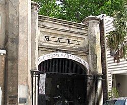
 Old-slave-mart-facade-sc1.jpg
The Old Slave Mart is a building located at 6 Chalmers Street in Charleston, South Carolina that once housed an antebellum slave auction gallery. Constructed in 1859, the building is believed to be the last extant slave auction facility in South Carolina. In 1975, the Old Slave Mart was added to the National Register of Historic Places for its role in Charleston's African-American history. Today, the building houses the Old Slave Mart Museum.
The Old Slave Mart was originally part of a slave market known as Ryan's Mart, which covered a large enclosed lot between Chalmers and Queen streets. The market was established in 1856 by Charleston City Councilman Thomas Ryan, after a citywide ban on public slave auctions made private facilities necessary. Slave auctions were held at the site until approximately 1863; in 1865, the Union Army occupied Charleston and closed Ryan's Mart. The Old Slave Mart Museum has operated on and off since 1938.


 South Carolina Aquarium
This was a really nice place, lots of animals, fish and other.
All the birds posed for pictures, they must be use to people.


So did you know that some Ray species have faces?!
I nearly lost my mind when I saw this guy, he posed for me as well.


This Bald Eagle have major attitude but you kind of expect that from an American right?
They had him in a nice habitat that lets you get this close to him, I've never been this close to one before so that was neat.


Angel Oak is a Southern live oak (Quercus virginiana) located in Angel Oak Park on Johns Island near Charleston, South Carolina. Angel Oak is estimated to be 500 years old. It stands 66.5 ft (20 m) tall, measures 28 ft (8.5 m) in circumference, and produces shade that covers 17,200 square feet (1,600 m2). Its longest branch distance is 187 ft. in length. Angel Oak was the 210th tree to be registered with the Live Oak Society.
Angel Oak is a tourist attraction for those visiting the Charleston, South Carolina area.
The tree stands on land that was part of Abraham Waight's 1717 land grant.

Well we had a really nice time here in Charleston, lots of good food, nice tours and lots of history.
It has a charm to it and a life lesson in the history of man, no man should ever own another, everyone has the right to freedom, respect and to fight for both. I hope we can learn from our past, I always hope that our future is better than our past and that we don't take for granted those hard learned lessons. Until next time be kind to one another.

Monday, December 12, 2016

Witchita, KS/Colorado


Wichita,KS
The city began as a trading post on the Chisholm Trail in the 1860s, then was incorporated in 1870. It subsequently became a key destination for cattle drives traveling north from Texas to access railroads, earning it the nickname "Cowtown". In the 1920s and 1930s, businessmen and aeronautical engineers established a number of successful aircraft manufacturing companies in Wichita including Beechcraft, Cessna, and Stearman Aircraft. The city transformed into a hub of U.S. aircraft production and became known as "The Air Capital of the World". Beechcraft, Cessna, (both now part of Textron Aviation) and other firms including Learjet, Airbus and Spirit AeroSystems continue to operate design and manufacturing facilities in Wichita today, and the city remains a major center of the U.S. aircraft industry.
 
The Chisholm Trail was a trail used in the post-Civil War era to drive cattle overland, from ranches in Texas to Kansas railheads. The portion of the trail marked by Jesse Chisholm went from his southern trading post near the Red River, to his northern trading post near Kansas City, Kansas.

Across the Arkansas River, the town of Delano became a popular entertainment destination for cattlemen thanks to its saloons, brothels, and lack of law enforcement. The area had a reputation for violence until local lawmen, Wyatt Earp among them, began to assertively police the cowboys.By the end of the decade, the cattle trade had moved west to Dodge City. Wichita annexed Delano in 1880.

I wish there was something more interesting to tell you about Kansas but it's Kansas, you know, where flat comes from.

Pueblo,CO
Pueblo is one of the largest steel-producing cities in the United States, for which reason Pueblo is referred to as the "Steel City". The Historic Arkansas River Project (HARP) is a river walk in the Union Avenue Historic Commercial District, and shows the history of the devastating Pueblo Flood of 1921.

Pikes Peak is the highest summit of the southern Front Range of the Rocky Mountains, in North America. The ultra-prominent 14,115-foot (4,302.31 m) fourteener is located in Pike National Forest, 12.0 miles (19.3 km) west by south (bearing 263°) of downtown Colorado Springs, Colorado. The mountain is named in honor of American explorer Zebulon Pike, who was unable to reach the summit. The summit is higher than any point in the United States east of its longitude.


In July 1893, Katharine Lee Bates wrote the song "America the Beautiful , after having admired the view from the top of Pikes Peak. It appeared in print in The Congregationalist, a weekly journal, on July 4, 1895. A plaque commemorating the words to the song was placed at the summit. During 1899, the Serbian physicist Nikola Tesla built his first working version of the Magnifying Transmitter in his laboratory some kilometers away from Colorado Springs, up in Pike's Peak, where he worked on his idea of wireless energy transmission and investigated the ionosphere and the telluric currents in the planets. Here, he proved that Earth is a good conductor, and he produced artificial bolt of 40 meters and millions of volts. He stated that during this year he discovered the Earth' stationary waves.


The Manitou Cliff Dwellings Museum exhibits relocated Anasazi Indian cliff dwellings. The Anasazi lived and roamed the Four Corners area of the United States Southwest from 1200 B.C. to A.D. 1300. The museum was established in 1904 and opened to the public in 1907.
The Anasazi did not live in the Manitou Springs area, but lived and built their cliff dwellings in the Four Corners area, several hundred miles southwest of Manitou Springs. The Manitou Cliff Dwellings were relocated to their present location in the early 1900s, as a museum, preserve, and tourist attraction. The stones were taken from a collapsed Anasazi site near Cortez in southwest Colorado, shipped by railroad to Manitou Springs, and assembled in their present form as Anasazi-style buildings closely resembling those found in the Four Corners. The project was done with the approval and participation of well-known anthropologist Dr. Edgar Lee Hewett, and Virginia McClurg, founder of the Colorado Cliff Dwelling Association.

Garden of the Gods is a public park located in Colorado Springs, Colorado, US. It was designated a National Natural Landmark in 1971.


The area was first called Red Rock Corral. Then, in August 1859, two surveyors who helped to set up Colorado City explored the site. One of the surveyors, M. S. Beach, suggested that it would be a "capital place for a beer garden". His companion, the young Rufus Cable, awestruck by the impressive rock formations, exclaimed, "Beer Garden! Why it is a fit place for the gods to assemble. We will call it the "Garden of the Gods."
In 1879 Charles Elliott Perkins, a friend of William Jackson Palmer, purchased 480 acres of land that included a portion of the present Garden of the Gods. Upon Perkins' death, his family gave the land to the City of Colorado Springs in 1909, with the provision that it would be a free public park. Palmer had owned the Rock Ledge Ranch and upon his death it was donated to the city.
Having purchased additional surrounding land, the City of Colorado Springs' park grew to 1,364 acres. In 1995 the Garden of the Gods Visitor and Nature Center was opened just outside the park.


So that's all I have for this leg of the trip, if your wondering why I only have one photo for Kansas it's not because I only had one photo of Kansas, it's because that was the most interesting photo of Kansas I had......
Until next time, be kind to one another.