Friday, March 10, 2017

Charleston/SC


Charleston: is the oldest and second-largest city in the U.S. state of South Carolina, the county seat of Charleston County, and the principal city in the Charleston–North Charleston–Summerville Metropolitan Statistical Area. The city lies just south of the geographical midpoint of South Carolina's coastline and is located on Charleston Harbor, an inlet of the Atlantic Ocean formed by the confluence of the Ashley and Cooper Rivers. Charleston had an estimated population of 132,609 in 2015. The population of the Charleston metropolitan area, comprising Berkeley, Charleston, and Dorchester Counties, was counted by the 2015 estimate at 727,689—the third-largest in the state—and the 78th-largest metropolitan statistical area in the United States.
It is known as one of the drunkest cities with over 200 bars in it's small downtown city space as well as being the fullest with over 400 restaurants in the area.


Arthur Ravenel Jr. Bridge
The Arthur Ravenel Jr. Bridge across the Cooper River opened on July 16, 2005, and was the second-longest cable-stayed bridge in the Americas at the time of its construction. The bridge links downtown Charleston with Mount Pleasant, and has eight lanes plus a 12-foot lane shared by pedestrians and bicycles. It replaced the Grace Memorial Bridge (built in 1929) and the Silas N. Pearman Bridge (built in 1966). They were considered two of the more dangerous bridges in America and were demolished after the Ravenel Bridge opened.


Fort Sumter is a sea fort in Charleston, South Carolina, notable for two battles of the American Civil War. It was one of a number of special forts planned after the War of 1812, combining high walls and heavy masonry, and classified as Third System, as a grade of structural integrity. Work started in 1829, but was incomplete by 1860, when South Carolina seceded from the Union.
The First Battle of Fort Sumter opened on April 12, 1861, when Confederate artillery fired on the Union garrison. These were the first shots of the war, and continued all day, watched by many civilians in a celebratory spirit. The fort had been cut off from its supply line and surrendered the next day. The Second Battle of Fort Sumter (September 8, 1863) was a failed attempt by the Union to retake the fort, dogged by rivalry between army and navy commanders. Although the fort was reduced to rubble, it remained in Confederate hands until it was evacuated as General Sherman marched through South Carolina in February 1865.

 On December 26, 1860, six days after South Carolina seceded from the Union, U.S. Army Major Robert Anderson abandoned the indefensible Fort Moultrie, spiking its large guns, burning its gun carriages, and taking its smaller cannon with him to be trained on the city. He secretly relocated companies E and H (127 men, 13 of them musicians) of the 1st U.S. Artillery to Fort Sumter on his own initiative, without orders from his superiors. He thought that providing a stronger defense would delay an attack by South Carolina militia. The fort was not yet complete at the time and fewer than half of the cannons that should have been available were in place, due to military downsizing by President James Buchanan.


In a letter delivered January 31, 1861, South Carolina Governor Pickens demanded of President Buchanan that he surrender Fort Sumter because," I regard that possession is not consistent with the dignity or safety of the State of South Carolina." Over the next few months repeated calls for evacuation of Fort Sumter from the government of South Carolina and then from Confederate Brigadier General P. G. T. Beauregard were ignored. Union attempts to resupply and reinforce the garrison were repulsed on January 9, 1861 when the first shots of the war, fired by cadets from the Citadel, prevented the steamer Star of the West, hired to transport troops and supplies to Fort Sumter, from completing the task. After realizing that Anderson's command would run out of food by April 15, 1861, President Lincoln ordered a fleet of ships, under the command of Gustavus V. Fox, to attempt entry into Charleston Harbor and supply Fort Sumter. The ships assigned were the steam sloop-of-war USS Pawnee, steam sloop-of-war USS Powhatan, transporting motorized launches and about 300 sailors (secretly removed from the Charleston fleet to join in the forced reinforcement of Fort Pickens, Pensacola, FL), armed screw steamer USS Pocahontas, Revenue Cutter USRC Harriet Lane, steamer Baltic transporting about 200 troops, composed of companies C and D of the 2nd U.S. Artillery, and three hired tug boats with added protection against small arms fire to be used to tow troop and supply barges directly to Fort Sumter. By April 6, 1861 the first ships began to set sail for their rendezvous off the Charleston Bar. The first to arrive was Harriet Lane, the evening of April 11, 1861.


The ugly side of History: 
Around 1719, the town's name began to be generally written Charlestown and, excepting those fronting the Cooper River, the old walls were largely removed over the next decade. Charlestown was a center for inland colonization of South Carolina, but remained the southernmost point of English settlement on the American mainland until the Province of Georgia was established in 1732. The first settlers primarily came from England and its colonies on Barbados and Bermuda. Protestant French, Scottish, Irish, and Germans immigrated, as did hundreds of Jews, predominately Sephardi. As late as 1830, Charleston continued to house the largest and wealthiest Jewish community in America. Because of the struggles of the English Reformation and particularly because the papacy long recognized James II's son as the rightful king of England, Scotland, and Ireland, openly practicing Roman Catholics were prohibited from settling in South Carolina throughout the colonial period. (Catholic emancipation did not proceed in earnest until after the onset of the American Revolution.)
By 1708, however, the majority of the colony's population were black Africans. They had been brought to Charlestown on the Middle Passage, first as "servants" and then as slaves. Of the estimated 400,000 Africans transported to North America for sale as slaves, 40% are thought to have landed at Sullivan's Island off Charlestown, a "hellish Ellis Island of sorts". With no official monument marking this role, the writer Toni Morrison organized a privately funded commemorative bench.  The Bakongo, Mbundu, Wolof, Mende, and Malinke peoples formed the largest groups. Free people of color also arrived from the West Indies, where wealthy whites took black consorts and color lines were (especially early on) looser among the working class. South Carolina continued to have a black majority until after the Great Migration of the early 20th century.
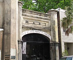
 Old-slave-mart-facade-sc1.jpg
The Old Slave Mart is a building located at 6 Chalmers Street in Charleston, South Carolina that once housed an antebellum slave auction gallery. Constructed in 1859, the building is believed to be the last extant slave auction facility in South Carolina. In 1975, the Old Slave Mart was added to the National Register of Historic Places for its role in Charleston's African-American history. Today, the building houses the Old Slave Mart Museum.
The Old Slave Mart was originally part of a slave market known as Ryan's Mart, which covered a large enclosed lot between Chalmers and Queen streets. The market was established in 1856 by Charleston City Councilman Thomas Ryan, after a citywide ban on public slave auctions made private facilities necessary. Slave auctions were held at the site until approximately 1863; in 1865, the Union Army occupied Charleston and closed Ryan's Mart. The Old Slave Mart Museum has operated on and off since 1938.


 South Carolina Aquarium
This was a really nice place, lots of animals, fish and other.
All the birds posed for pictures, they must be use to people.


So did you know that some Ray species have faces?!
I nearly lost my mind when I saw this guy, he posed for me as well.


This Bald Eagle have major attitude but you kind of expect that from an American right?
They had him in a nice habitat that lets you get this close to him, I've never been this close to one before so that was neat.


Angel Oak is a Southern live oak (Quercus virginiana) located in Angel Oak Park on Johns Island near Charleston, South Carolina. Angel Oak is estimated to be 500 years old. It stands 66.5 ft (20 m) tall, measures 28 ft (8.5 m) in circumference, and produces shade that covers 17,200 square feet (1,600 m2). Its longest branch distance is 187 ft. in length. Angel Oak was the 210th tree to be registered with the Live Oak Society.
Angel Oak is a tourist attraction for those visiting the Charleston, South Carolina area.
The tree stands on land that was part of Abraham Waight's 1717 land grant.

Well we had a really nice time here in Charleston, lots of good food, nice tours and lots of history.
It has a charm to it and a life lesson in the history of man, no man should ever own another, everyone has the right to freedom, respect and to fight for both. I hope we can learn from our past, I always hope that our future is better than our past and that we don't take for granted those hard learned lessons. Until next time be kind to one another.

Monday, December 12, 2016

Witchita, KS/Colorado


Wichita,KS
The city began as a trading post on the Chisholm Trail in the 1860s, then was incorporated in 1870. It subsequently became a key destination for cattle drives traveling north from Texas to access railroads, earning it the nickname "Cowtown". In the 1920s and 1930s, businessmen and aeronautical engineers established a number of successful aircraft manufacturing companies in Wichita including Beechcraft, Cessna, and Stearman Aircraft. The city transformed into a hub of U.S. aircraft production and became known as "The Air Capital of the World". Beechcraft, Cessna, (both now part of Textron Aviation) and other firms including Learjet, Airbus and Spirit AeroSystems continue to operate design and manufacturing facilities in Wichita today, and the city remains a major center of the U.S. aircraft industry.
 
The Chisholm Trail was a trail used in the post-Civil War era to drive cattle overland, from ranches in Texas to Kansas railheads. The portion of the trail marked by Jesse Chisholm went from his southern trading post near the Red River, to his northern trading post near Kansas City, Kansas.

Across the Arkansas River, the town of Delano became a popular entertainment destination for cattlemen thanks to its saloons, brothels, and lack of law enforcement. The area had a reputation for violence until local lawmen, Wyatt Earp among them, began to assertively police the cowboys.By the end of the decade, the cattle trade had moved west to Dodge City. Wichita annexed Delano in 1880.

I wish there was something more interesting to tell you about Kansas but it's Kansas, you know, where flat comes from.

Pueblo,CO
Pueblo is one of the largest steel-producing cities in the United States, for which reason Pueblo is referred to as the "Steel City". The Historic Arkansas River Project (HARP) is a river walk in the Union Avenue Historic Commercial District, and shows the history of the devastating Pueblo Flood of 1921.

Pikes Peak is the highest summit of the southern Front Range of the Rocky Mountains, in North America. The ultra-prominent 14,115-foot (4,302.31 m) fourteener is located in Pike National Forest, 12.0 miles (19.3 km) west by south (bearing 263°) of downtown Colorado Springs, Colorado. The mountain is named in honor of American explorer Zebulon Pike, who was unable to reach the summit. The summit is higher than any point in the United States east of its longitude.


In July 1893, Katharine Lee Bates wrote the song "America the Beautiful , after having admired the view from the top of Pikes Peak. It appeared in print in The Congregationalist, a weekly journal, on July 4, 1895. A plaque commemorating the words to the song was placed at the summit. During 1899, the Serbian physicist Nikola Tesla built his first working version of the Magnifying Transmitter in his laboratory some kilometers away from Colorado Springs, up in Pike's Peak, where he worked on his idea of wireless energy transmission and investigated the ionosphere and the telluric currents in the planets. Here, he proved that Earth is a good conductor, and he produced artificial bolt of 40 meters and millions of volts. He stated that during this year he discovered the Earth' stationary waves.


The Manitou Cliff Dwellings Museum exhibits relocated Anasazi Indian cliff dwellings. The Anasazi lived and roamed the Four Corners area of the United States Southwest from 1200 B.C. to A.D. 1300. The museum was established in 1904 and opened to the public in 1907.
The Anasazi did not live in the Manitou Springs area, but lived and built their cliff dwellings in the Four Corners area, several hundred miles southwest of Manitou Springs. The Manitou Cliff Dwellings were relocated to their present location in the early 1900s, as a museum, preserve, and tourist attraction. The stones were taken from a collapsed Anasazi site near Cortez in southwest Colorado, shipped by railroad to Manitou Springs, and assembled in their present form as Anasazi-style buildings closely resembling those found in the Four Corners. The project was done with the approval and participation of well-known anthropologist Dr. Edgar Lee Hewett, and Virginia McClurg, founder of the Colorado Cliff Dwelling Association.


Garden of the Gods is a public park located in Colorado Springs, Colorado, US. It was designated a National Natural Landmark in 1971.


The area was first called Red Rock Corral. Then, in August 1859, two surveyors who helped to set up Colorado City explored the site. One of the surveyors, M. S. Beach, suggested that it would be a "capital place for a beer garden". His companion, the young Rufus Cable, awestruck by the impressive rock formations, exclaimed, "Beer Garden! Why it is a fit place for the gods to assemble. We will call it the "Garden of the Gods."
In 1879 Charles Elliott Perkins, a friend of William Jackson Palmer, purchased 480 acres of land that included a portion of the present Garden of the Gods. Upon Perkins' death, his family gave the land to the City of Colorado Springs in 1909, with the provision that it would be a free public park. Palmer had owned the Rock Ledge Ranch and upon his death it was donated to the city.
Having purchased additional surrounding land, the City of Colorado Springs' park grew to 1,364 acres. In 1995 the Garden of the Gods Visitor and Nature Center was opened just outside the park.


So that's all I have for this leg of the trip, if your wondering why I only have one photo for Kansas it's not because I only had one photo of Kansas, it's because that was the most interesting photo of Kansas I had......
Until next time, be kind to one another.


Sunday, September 4, 2016

Mount Rushmore/Crazy Horse in SD

                                 Mount Rushmore National Memorial


It is a sculpture carved into the granite face of Mount Rushmore, a granite batholith formation in the Black Hills in Keystone, South Dakota, United States.
Sculpted by Danish-American Gutzon Borglum and his son, Lincoln Borglum, Mount Rushmore features 60-foot (18 m) sculptures of the heads of four United States presidents: George Washington (1732–1799), Thomas Jefferson (1743–1826), Theodore Roosevelt (1858–1919), and Abraham Lincoln (1809–1865).
Construction on the memorial began in 1927, and the presidents' faces were completed between 1934 and 1939. Upon Gutzon Borglum's death in March 1941, his son Lincoln Borglum took over construction. Although the initial concept called for each president to be depicted from head to waist, lack of funding forced construction to end in late October 1941.
It took 400 men and 11 years to complete the sculpture but it is a testament to hard work, great engineering and art.

The carving of Mount Rushmore involved the use of dynamite, followed by the process of "honeycombing", a process where workers drill holes close together, allowing small pieces to be removed by hand. In total, about 450,000 short tons (410,000 t) of rock were blasted off the mountainside. You can see all of the rock tailing's still piled in front of the sculptures.

Fun fact In a canyon behind the carved faces is a chamber, cut only 70 feet (21 m) into the rock, containing a vault with sixteen porcelain enamel panels. The panels include the text of the Declaration of Independence and the Constitution, biographies of the four presidents and Borglum, and the history of the U.S. The chamber was created as the entrance-way to a planned "Hall of Records"; the vault was installed in 1998.
It is directly behind Lincolns head, originally it was planned to hold National Archives and letters of our nations beliefs, treasures and important documents but was later turned into a hall of records and then abandoned with what few things that had already been added, the way to the cave may have become unstable, or maybe those national treasure movies are right and there really is something more in there.


                      Crazy Horse Memorial


The Crazy Horse Memorial is a mountain monument under construction on privately held land in the Black Hills, in Custer County, South Dakota. It depicts Crazy Horse, an Oglala Lakota warrior, riding a horse and pointing into the distance. The memorial was commissioned by Henry Standing Bear, a Lakota elder, to be sculpted by Korczak Ziolkowski. The monument has been in progress since 1948 and is far from completion.  If completed, it may become the world's largest sculpture, as well as the first non-religious statue to hold this record since 1967, in comparison to the Rushmore monument in size you could fit all of the Rushmore sculpture into the Crazy Horse head portion alone. The work load is larger with less people, Rushmore had 400 men and 11 years, whereas Crazy Horse has had only 15 men over the last 60 or so years, the first 5 years where only Korczak Ziolkowski was working on it himself, then later by his son's with him and now since his death his son's and the other few workers.
Crazy Horse was a Native American war leader of the Oglala Lakota. He took up arms against the U.S. Federal government to fight against encroachments on the territories and way of life of the Lakota people. His most famous actions against the U.S. military included the Fetterman Fight (21 December 1866), and the Battle of the Little Bighorn (25–26 June 1876). He surrendered to U.S. troops under General Crook in May 1877, due to the fact that his wife has TB and needed medicine, he was fatally wounded by a military guard while "allegedly" resisting imprisonment at Camp Robinson in present-day Nebraska, though it known that he thought he was being taken to meet someone of higher rank to disscuss a peace treaty, when he realized they were taking him to the fort prison he reached for his knife and was shot in the back and leg by the armed men, he was then place in the jail where he died of the wounds. He ranks among the most notable and iconic of Native American tribal members and was honored by the U.S. Postal Service in 1982 with a 13¢ postage stamp as part of its Great Americans series. 

I personally think he would be insulted to be honored by a .13 cent stamp but he probably would appreciate the memorial of himself. 

This trip was really fun and I enjoyed learning more about a culture and our nation, I wish evryone a good week and a happy life, until next time be kind to one another.


Monday, August 15, 2016

Anaconda MT./Yellowstone WY.


Anaconda was founded by Marcus Daly, one of the Copper Kings, who financed the construction of a smelter on nearby Warm Springs Creek to process copper ore from the Butte mines. In June 1883, Daly filed for a town plat for “Copperopolis,” but that name was already used by another mining town in Meagher County. Instead, Daly accepted the name "Anaconda," suggested by the United States postmaster of the time, Clinton Moore. When Montana was admitted as a state in 1889, Daly lobbied to have the capital moved here, but it stayed in Helena, a location supported by rival William Andrews Clark.

The National Bison Range (NBR) is a National Wildlife Refuge located in western Montana established in 1908 to provide a sanctuary for the American bison. The NBR is one of the oldest National Wildlife Refuges in the United States. The size of the bison herd at the NBR is relatively small, numbering between 350 and 500 individuals.


Big Horned sheep and Antelope were just a few of the other animals we saw here.


A waterfall near Phillipsburg, MT. where we went Sapphire mining.


Yellowstone National Park is a national park located primarily in the U.S. state of Wyoming, although it also extends into Montana and Idaho. It was established by the U.S. Congress and signed into law by President Ulysses S. Grant on March 1, 1872. Yellowstone, the first National Park in the U.S. and widely held to be the first national park in the world, is known for its wildlife and its many geothermal features, especially Old Faithful Geyser, one of the most popular features in the park.


Yellowstone National Park spans an area of 3,468.4 square miles (8,983 km2),  comprising lakes, canyons, rivers and mountain ranges. Yellowstone Lake is one of the largest high-elevation lakes in North America and is centered over the Yellowstone Caldera, the largest supervolcano on the continent.


In 1806, John Colter, a member of the Lewis and Clark Expedition, left to join a group of fur trappers. After splitting up with the other trappers in 1807, Colter passed through a portion of what later became the park, during the winter of 1807–1808. He observed at least one geothermal area in the northeastern section of the park, near Tower Fall. After surviving wounds he suffered in a battle with members of the Crow and Blackfoot tribes in 1809, Colter described a place of "fire and brimstone" that most people dismissed as delirium; the supposedly imaginary place was nicknamed "Colter's Hell". Over the next 40 years, numerous reports from mountain men and trappers told of boiling mud, steaming rivers, and petrified trees, yet most of these reports were believed at the time to be myth.


A good view of how thin the crust of land laying over the basin's really is, it is as thin as pie crust in many areas, though to look at the ground it would seem normal, it is anything but.
Hot boiling water lye just under the surface.


 A boiling waterfall, hot boiling sulfuric Basin water pours into the River creating a sizzling, steaming combination.


Little known fact, A man named Gerald Ford whom was not only an American politician who served as the 38th President of the United States from 1974 to 1977, as well as being a member of the Boy Scouts of America was also a Park Ranger in the 30's for Yellowstone National Park, he gave tours and lessons about the park, he stayed and worked in the Uncle Tom lookout area, around the upper and lower falls area of the park, it was where the staff housing was at the time and is now a parking lot for the stop.


 The most famous geyser in the park, and perhaps the world, is Old Faithful Geyser, located in Upper Geyser Basin. Castle Geyser, Lion Geyser and Beehive Geyser are in the same basin. The park contains the largest active geyser in the world—Steamboat Geyser in the Norris Geyser Basin. A study that was completed in 2011 found that at least 1283 geysers have erupted in Yellowstone. Of these, an average of 465 are active in a given year. Yellowstone contains at least 10,000 geothermal features altogether. Half the geothermal features and two-thirds of the world's geysers are concentrated in Yellowstone.


 With almost two million visitors a week in the summer months you can imagine just how popular this park really is, that's on the same scale as Disney world, with so many examples of God's creation and beauty it is no wonder why it inspires such awe and draws people of all nations in.

View of the Grand Teton Mountain's , though I only drove through this park the scenery was amazing. It always amazes me how mother nature can bring people together, while here we saw people of all nations and creeds and accents, no one fought, no one was angry, they were all just soaking in the great wonder that is our home. It just goes to prove that the only true peacemaker and keeper is our creator. May our future bring a great peace, until next time be kind to one another.

Thursday, July 14, 2016

Seattle Washington/Vancouver BC

Seattle Washington:
The Seattle area was previously inhabited by Native Americans for at least 4,000 years before the first permanent European settlers. Arthur A. Denny and his group of travelers, subsequently known as the Denny Party, arrived from Illinois via Portland, Oregon, on the schooner Exact at Alki Point on November 13, 1851. The settlement was moved to the eastern shore of Elliott Bay and named "Seattle" in 1852, after Chief Si'ahl of the local Duwamish and Suquamish tribes.
Seattle is also home to more big businesses than you even realize, I was surprised to learn of just how many, as a matter of fact Elliott Bay was the place where one of them got its start, you might recognize it, its called E-Bay, or maybe you've heard of google?, Amazon?, Nordstroms?,  or maybe Starbucks Coffee? That's right and many more.

Seattle has a history of boom-and-bust cycles, like many other cities near areas of extensive natural and mineral resources. Seattle has risen several times economically, then gone into precipitous decline, but it has typically used those periods to rebuild solid infrastructure.
The first such boom, covering the early years of the city, rode on the lumber industry. (During this period the road now known as Yesler Way won the nickname "Skid Road", supposedly after the timber skidding down the hill to Henry Yesler's sawmill. The later dereliction of the area may be a possible origin for the term which later entered the wider American lexicon as Skid Row.)
Like much of the American West, Seattle saw numerous conflicts between labor and management, as well as ethnic tensions that culminated in the anti-Chinese riots of 1885–1886. This violence originated with unemployed whites who were determined to drive the Chinese from Seattle (anti-Chinese riots also occurred in Tacoma). In 1900, Asians were 4.2% of the population. Authorities declared martial law and federal troops arrived to put down the disorder.
Seattle achieved sufficient economic success that when the Great Seattle Fire of 1889 destroyed the central business district, a far grander city-center rapidly emerged in its place.
The Great Seattle Fire was a fire that destroyed the entire central business district of Seattle, Washington, on June 6, 1889. The fire burned for several hours, destroying 25 blocks and causing as much as $20 million in damage ($527 million in today's dollars). As a result of the fire, streets in the Pioneer Square neighborhood in Seattle were elevated 22 feet (6.7 m) above the pre-fire street level and new buildings made of wood were banned.
Which leads us to one of Seattle's least known and very cool secrets, there's a city underground!


Despite the magnitude of destruction, the rebuilding effort began quickly. Rather than starting over somewhere else, Seattle's citizens decided to rebuild.
Seattle rebuilt from the ashes quickly. A new building ordinance resulted in a downtown of brick and stone buildings, rather than wood; and at the same time the street levels were raised by up to 22 feet.
Due to a fast growing population and limited space they chose rebuild the old city, then built all the sidewalks and roads on top of the old and added two more stories to the top of the original buildings, so the first floor in the buildings on Pioneer Square are actually the 2nd floor.

 Skylights were put into the sidewalks they built so the underground stores would still have lighting. They still work today!
You could walk over these throughout the city and never know you were walking over the old underground.


                                                        Vancouver,BC!

The original settlement, named Gastown, grew up on clearcuts on the west edge of the Hastings Mill logging sawmill's property, where a makeshift tavern had been set up on a plank between two stumps and the proprietor, Gassy Jack, persuaded the curious millworkers to build him a tavern, on 1 July 1867. From that first enterprise, other stores and some hotels quickly appeared along the waterfront to the west. Gastown became formally laid out as a registered townsite dubbed Granville, B.I. ("B.I" standing for "Burrard Inlet"). As part of the land and political deal whereby the area of the townsite was made the railhead of the CPR, it was renamed "Vancouver" and incorporated shortly thereafter as a city, in 1886. By 1887, the transcontinental railway was extended to the city to take advantage of its large natural seaport, which soon became a vital link in a trade route between the Orient, Eastern Canada, and Europe.

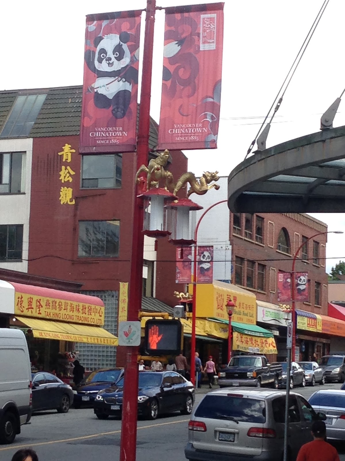
 Chinatown in Vancouver, British Columbia is Canada's largest Chinatown.
Chinatown was once known for its neon signs but like the rest of the city lost many of the spectacular signs to changing times and a new sign by law passed in 1974. The last of these was the Ho Ho sign (which showed a rice bowl and chop sticks) which was removed in 1997. Ongoing efforts at revitalization include efforts by the business community to improve safety by hiring private security; looking at new marketing promotions and introducing residential units into the neighbourhood by restoring and renovating some of the heritage buildings. Current focus is on the restoration and adaptive reuse of the distinctive Association buildings.

Once the epicenter for commerce has now deteriorated to becoming the ghetto. 
These are some of the art pieces that have been created to try to bring Chinatown back from decay. this is a large scale abacus.

Some of the markets in Chinatown that are still surviving.


Views from the Vancouver lookout, it's thier version of a space needle.


The Lions Gate Bridge, opened in 1938, officially known as the First Narrows Bridge, is a suspension bridge that crosses the first narrows of Burrard Inlet and connects the City of Vancouver, British Columbia, to the North Shore municipalities of the District of North Vancouver, the City of North Vancouver, and West Vancouver. The term "Lions Gate" refers to The Lions, a pair of mountain peaks north of Vancouver. Northbound traffic on the bridge heads in their general direction. A pair of cast concrete lions, designed by sculptor Charles Marega, were placed on either side of the south approach to the bridge in January, 1939.

Canada's First Nation's 
Archaeological records indicate the presence of Aboriginal people in the Vancouver area from 8,000 to 10,000 years ago. The city is located in the traditional territories of the Squamish, Musqueam, and Tseil-Waututh (Burrard) peoples of the Coast Salish group. They had villages in various parts of present-day Vancouver, such as Stanley Park, False Creek, Kitsilano, Point Grey and near the mouth of the Fraser River.


These Statues (not totems) tell stories of the people and tribes, they are recreations of the originals done by remaining First Nation's artist's and donated to Stanley Park. 


I absolutely loved our visit to Canada, it was a beautiful place in Vancouver with lot's of history and culture.
Our own country is in great turmoil currently and I feel that all to often we forget our own history and the lessons that it should have taught us, it's important to know where we came from and the mistakes that were made, it's what keeps people from making them again.
I would like to invite everyone to remember and forgive so that our future can be a safe and bright one.
Be kind to one another. Until next time.